The Arctic | Greenland | Tripcode: OTL14-27
14 Days 13 Nights | Sep 06, 2027 - Sep 19, 2027
All itineraries are for guidance only. Programs may vary depending on ice, weather, and wildlife conditions. Landings are subject to site availability, permissions, and environmental concerns per State and AECO regulations. Official sailing plans and landing slots are scheduled before the start of the season, but the expedition leader will determine the final plan. Flexibility is paramount for expedition cruises. Our vessel's average cruising speed is 10.5 knots. The probability of reaching Isle de France in the second week of September with m/v Hondius is about 90% (based on ice charts from the last three years).
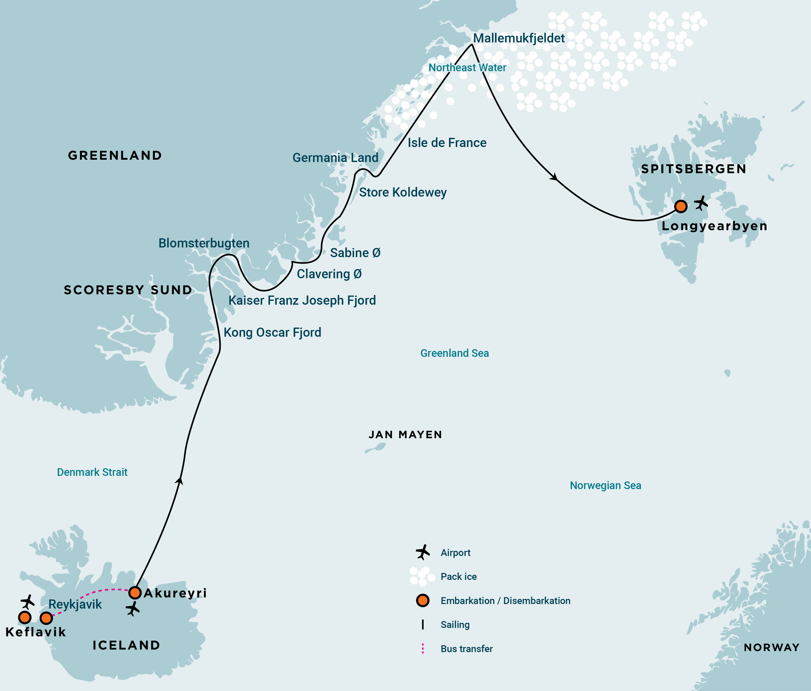
Venturing to the dramatic, rugged coastline of Northeast Greenland, you'll enter the world's largest fjord, Scoresby Sund, encountering whales, seabirds, and musk oxen before voyaging north through the most beautiful straits and fjords. Along the way, sea ice, polar bears, and landing opportunities will guide your Arctic adventure through historical, natural, and scientific wonder.
Your journey begins in the morning, departing Akureyri. By request, you can transfer via chartered bus (T) from the bus stop Harpa Concert Hall and Conference Centre at Austurbakki, Reykjavik (the meeting point) to the ship in Akureyri (the embarkation point). You arrive in the afternoon after a six-hour drive through the beautiful landscapes of northern Iceland.
PLEASE NOTE: This transfer (T) must be booked and paid for in advance.
In the early evening, the ship departs from the port of Akureyri, where we often see whales at the mouth of the fjord. At night, we cross the Arctic Circle close to the island of Grimsey.
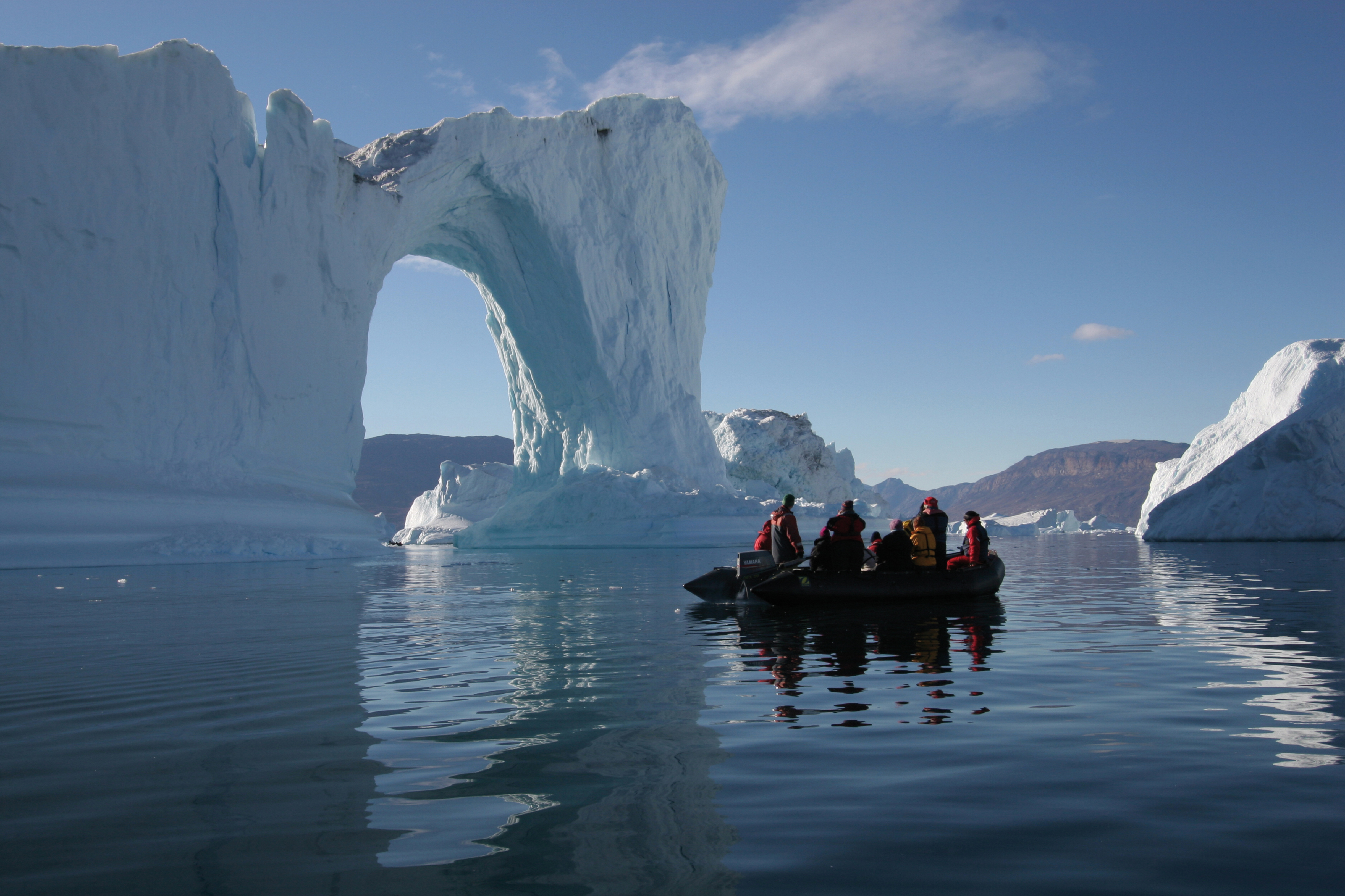
Ocean life beneath the Northern Lights
We will sail northward, following warmer waters, before entering colder seas, where a multitude of sea life (whales, seals, seabirds) can be found in the mixing zones of these waters. A sea day grants you the opportunity to spot whales and seabirds – and, at night, the magical Northern Lights.
In the footsteps of Arctic explorers
In the morning, we will find ourselves in the mouth of Kong Oscar Fjord in the strait between the island of Isikaja and the mainland. Until 30 years ago, Isikaja was connected to the mainland by a glacier.
On the south side, we will land at Wegener Halvöya and pay a tribute to this great explorer. Another possibility is Antarctic Havn, where muskoxen are often spotted. This bay is named for the ship Antarctic, used by Arctic explorer Alfred Gabriel Nathorst in 1899, while searching for the survivors of Salomon August Andrée's failed attempt to reach the North Pole by air balloon.
At Ymers Ø, we will aim to land at Karl Jakobsens Bugt, near a historic trapper's cabin. A few hundred meters east, at Botaniker Bugt, ruined dwellings of the Thule culture people from about two centuries ago can be encountered. A walk into Juluts dal provides good chances to a variety of polar fauna, including musk oxen, Arctic hares, and ptarmigans. A spectacular transit through the Antarctic Sund firmly places us in the most Alpine landscapes of the journey, with peaks on either side of the fjord in excess of 1000 meters.
We will aim to land in Blomsterbugt (Flower Valley) with excellent walking opportunities, opposite Teufelsloss (Devil's Castle), a spectacular mountain with impressive layered geology, described by Austro-Hungarian explorer Julius Payer as "A cubic rock colossus stretched far out into the fjord."
Remains of the Thule Culture at Eskimonaes
We hope to land at Eskimonaes on the southern shore of Clavering Ø, where Douglas Clavering met a small group of Thule culture people in 1823. This group represents the only living Thule people ever seen in Northeast Greenland. The remains of their existence can be found across Greenland, including indications that they traded and interacted with Norse settlers in some form.
Arctic islands with lesser-known history
Sir Edward Sabine performed his pendulum experiments on Sabine Ø (formerly Inner Pendulum Island) in 1823. Carl Koldewey built a station there in 1869 at Germaniahavn. On its south side is Hvalros Island, where the population of walruses is increasing again. From this day onward, sailing north, we will experience daylight round the clock.
When sailing into Dove Bugt, we may, depending on the conditions, land at Hochstetter Forland, Store Koldewey, named by the second German Polar Expedition of Carl Koldewey at Kap Alf Trolle, or Kap Ahrend. Kap Bismarck, close to Germania Land, is also a possibility. We are now in Muskox territory, and the southernmost realm of some lonely Arctic wolves in Greenland.
We will sail past Danmarks Havn Sirius Patrol Station and land on the east side of Germania Land, for instance, at Thomas Thomsen Naes.
Depotneaset on Stormlandet is another possibility. We are now in muskox territory, and the southernmost realm of lonely Arctic wolves in Greenland, in a region where we have never been with our ships.
If ice and weather conditions are favorable, we land at the south side of Isle de France, which was first reached by the Duke of Orleans on the Belgica in 1905. We aim to go ashore at Kap St. Jacques, where, under the guidance of an archeologist from the National Greenland Museum, we can see the remains of the Independence II culture. We may also land at the ice-free area on the north side of the island.
Into the Northeast Water Polynya
When sailing by Norske Øer, where we possibly land, we are sailing in territories where we have not been before. We hope to reach Northeast Water, a semi-permanently open water area in extreme Northeast Greenland, where relatively warm bottom water from the sea rises to the surface. It is a water rich with seals, whales, polar bears, and seabirds. We will try to get to Mallemukfjellet, at latitude 80'11 N', to the northernmost colony of northern fulmars, with young still on the ledges. We will be on guard to observe the rare Ross gull, which winters in the central polar seas.
In the fringes of the pack ice
Working our way south-east in the outer fringes of the pack ice, we continue to observe Arctic marine mammals and seabirds, who thrive in this otherworldly habitat.
After leaving the shores and pack ice of Greenland behind, we now find ourselves in the open sea. We sail eastward, across the Greenland Sea, following the northernmost branch of the warm Gulf Stream toward Spitsbergen (Svalbard), along with migrating whales. If time allows, we may land late in the day at the walrus haul-out at Poolepynten.
Largest town, biggest island
In Longyearbyen, the administrative center of Spitsbergen (Svalbard), you may enjoy strolling through this former mining town, home to the parish church, the Museum of Arctic Exploration, and the Svalbard Museum, all fascinating attractions. Further opportunities for exploring Svalbard and Longyearbyen's surroundings can be found here before you depart for Oslo and continue your onward journey.